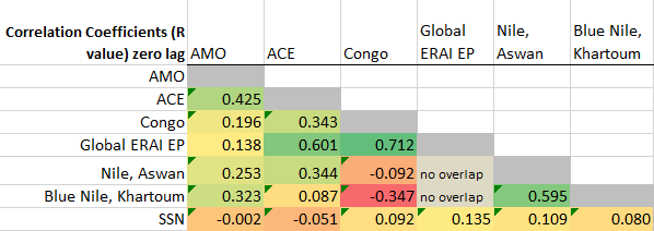
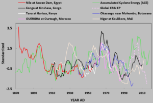
Many African rivers indicate a statistically exceptional correlation to the Atlantic Hurricane pattern, as exemplified by the Accumulated Cyclone Energy Index (ACE). The featured chart summarizes some explorations I have made of this while exploring another collaboration. Please note that unless otherwise obvious, most of the time series work featured in this post is for the 60 month average, which filters out higher frequency oscillations and patterns in order to focus on climate scales.
In particular the Congo River, whose watershed lies solidly underneath the Equatorial Trough (ET) is exemplary of this connection. Because the ET swings north and south across much of Africa every year (causing and sustaining the Sahel in the process), it is also not surprising that much of the rest of the continent also shares this connection. Equally interesting is the somewhat impressive negative correlation of the Blue Nile to the Congo. My colleagues will also have something to contribute on this topic of precipitation, but for now my interest is focused on the Congo and its many neighbors which follow. This is only a blog, but any are free to double check.
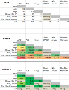
Any are free to reproduce this table as well, which rounds out the featured image and defines how I arrived at the claim of a statistically exceptional correlation.
For as long as scientists have evoked climate change as an existential crisis, they have had an opportunity to connect to hurricanes. And they have attempted to do so many times. Yet, no climate change scientist has correctly and transparently forecast any hurricane season. In fact no scientist has. This is likely because the collective scientists believe that carbon dioxide emissions are the primary driver. It would be a simple exercise to add to the table above to demonstrate that CO2 emissions do not remotely correlate to the ACE. In contrast, my peer reviewed work [1] reinforces that the Sun drives our climate.
Climate change scientists are fixated on ocean heat as the cause of a hurricane and water as the effect. That ocean heat is implied by climate scientists to originate from fossil fuels. Yet the surface temperatures across most of the oceans are simply the everyday consequences of wind and water, which both are solar forced when all is said and done.
The ACE hurricane factor is the green line. The Congo, the Nile and other interesting time series are also included.
As this curve along with a prior post also illustrates, the ACE (green curve) is highly correlated to the full atmosphere thickness global moisture index (EP). This means that our Earth’s water falling out of the sky is tightly integrated with more hurricane energy. As [1] again shows, more solar energy reaching our planet is directly and significantly correlated with more water falling across the ET. That appears to simply indicate that greater solar energy translates ultimately to greater hurricane energy, a metric that compares favorably to something much better than any inaccurate climate model, the UCAR ERAI full atmospheric satellite integration project. This goes especially for the “evaporation minus precipitation” (EP) parameter, which this site often largely revolves around.
For example, the total global ERAI EP index integrated through space and time over nearly 4 continuous decades, shows the highest correlation to the Congo of all of the interesting correlations featured here. There appears to be no further interest on the part of UCAR to update this parameter. Perhaps I’ll give that a try someday.

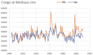
Spring or Fall, Summer or Winter, The Congo’s flow patterns are consistent over centennial time frames.
I’ve rounded out some aspects of this important river with data representations above and below.

This stochastic landscape of the Congo’s flows show the consistent patterns, along with the remarkable surge in flows over the mid 1960s.
This isn’t rocket science. More Solar radiation over climatological time scales leads to more equatorial rain. More equatorial rain leads to more flows in the Congo and also to more powerful hurricanes in the Atlantic. When the Congo is flooding and running higher, over a 60 month average, the ACE is higher. Perhaps that historical data, and this draft treatment can stimulate greater attention so that real advances in decadal hurricane energy forecasts might be within reach.
I’ll revisit sometime soon to delineate the interesting atmospheric moisture circulation connection that dovetails into this post. I’ve already made the plots.
[1] Wallace, M.G., 2019, Application of lagged correlations between solar cycles and hydrosphere components towards sub-decadal forecasts of streamflows in the Western US. Hydrological Sciences Journal, Oxford UK Volume 64 Issue 2. doi: 10.1080/02626667.2019.
Other acknowledgements and sources.
Many Thanks to Laurenz, L., and S. Lüning for inviting me to participate in their recent study on Africa rainfall patterns. The views in this blog are however mine and do not necessarily reflect any of their opinions or products, even as we all work hard to explore solar and other natural connections to rainfall and hydrology.
ACE from http://www.aoml.noaa.gov/hrd/hurdat/comparison_table.html
AMO from http://www.esrl.noaa.gov/psd/data/correlation/amon.us.long.data
Global EP from http://www.cgd.ucar.edu/cas/catalog/reanalysis/budgets/nnarbudgets.html
Global Runoff Data Center (GRDC) Koblenz, Germany, is the source of all river data in this post.
*If you want to render a Dunning-Kruger climate authority speechless, ask for the citation to the peer reviewed laboratory experiment which proves that CO2 stores more heat than dry air.
 17971total visits,18visits today


